Navionics chart symbols and meanings are a crucial component of marine navigation, acting as a visual guide for sailors, fishermen, and other maritime enthusiasts. These symbols provide valuable information about the underwater topography, navigational aids, hazards, and other important features of the waterway, ensuring safe and efficient passage. Whether you're planning an adventurous voyage, exploring new fishing spots, or simply cruising along the coast, understanding the navionics chart symbols and meanings is the key to unlocking the wonders and complexities of the marine world. So, let's dive in and discover the fascinating world of navionics chart symbols and their meanings.
What You'll Learn
- What are some common symbols used on Navionics charts and what do they mean?
- How can I familiarize myself with the various symbols and their meanings on Navionics charts?
- Are there any specific symbols on Navionics charts that I should pay particular attention to?
- Are there any resources or guides available that provide a comprehensive list of Navionics chart symbols and their meanings?
- Can I customize the symbols and their meanings on my Navionics charts to better suit my navigation needs?
![]()
What are some common symbols used on Navionics charts and what do they mean?
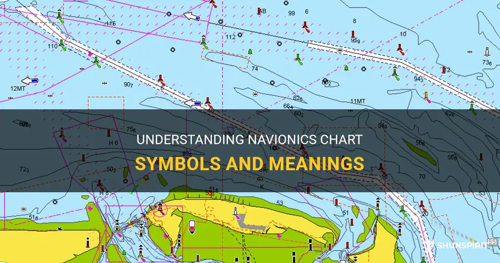
Navionics charts are widely used by boaters and navigators to plan and navigate their journeys on the water. These charts contain a variety of symbols and icons that convey important information about the features, hazards, and facilities found on the waterways. Understanding these symbols is crucial for safe and efficient navigation. Here are some common symbols used on Navionics charts and what they mean:
- Depths: The most commonly used symbol on Navionics charts is the depth contour lines. These lines indicate the depth of the water at specific intervals. The depth is measured in meters or feet and is crucial for determining the passage of boats and ships. The contours are typically represented by a series of concentric lines, with the deepest parts of the water marked by darker lines.
- Navigational Aids: Navionics charts feature various symbols for navigational aids such as buoys, beacons, and lighthouses. These symbols help boaters identify the location and type of aids to navigation. Buoys are represented by a variety of different shapes and colors, each indicating a specific navigational purpose. Lighthouses are depicted as tall structures with a red or white light symbol.
- Hazard Markers: Navionics charts also display symbols for various hazards present in the water. These can include submerged rocks, wrecks, reefs, and shoals. The symbols used for hazards are often depicted as small triangles or squares to represent the danger. It is essential to be aware of these symbols to avoid potential hazards while navigating.
- Marinas and Facilities: Navionics charts provide valuable information about marinas, harbors, and facilities along the waterways. The symbols used to represent these features can vary, but typically consist of small icons or labels indicating amenities such as fuel docks, pump-out stations, boat ramps, and mooring points.
- Bridges and Overhead Clearance: For boaters navigating under bridges, Navionics charts often include symbols indicating the bridge locations, heights, and clearance information. These symbols help boaters plan their routes and ensure their vessel can safely pass under the structure without any clearance issues.
- Ports and Anchorages: Navionics charts also feature symbols for ports and anchorages. These symbols can vary depending on the size and type of the facility. Ports are often represented by large icons or labels, while anchorages are depicted by smaller symbols indicating a safe area to drop anchor in.
- Fishing Spots: For anglers, Navionics charts offer valuable information on fishing spots and hotspots. These symbols can include icons such as fish or hooks, indicating areas where fish are frequently found. This information aids fishermen in planning their trips and maximizing their chances of a successful catch.
It's important to note that the symbols used on Navionics charts can vary based on the scale and edition of the chart. It is essential to refer to the chart's key or legend to ensure accurate interpretation of the symbols. Additionally, Navionics regularly updates their charts, so it's important to stay updated on any changes or new symbols that may be introduced.
Overall, understanding the symbols used on Navionics charts is crucial for safe and efficient navigation on the water. By familiarizing yourself with these symbols and their meanings, you can navigate with confidence and make informed decisions while out on the water.
The Hidden Meaning Behind the Acorn Symbol Unveiled
You may want to see also
![]()
How can I familiarize myself with the various symbols and their meanings on Navionics charts?
Navionics charts are widely used by boaters and marine enthusiasts to navigate waterways around the world. These charts are packed with helpful information, but they can be overwhelming for someone who is new to them. To make the most of your Navionics charts, it's important to familiarize yourself with the various symbols and their meanings. Here are some tips to help you get started:
- Use the Navionics Chart Viewer: One of the easiest ways to familiarize yourself with the symbols on Navionics charts is to use the Navionics Chart Viewer. This online tool allows you to explore different areas and zoom in on specific features. As you explore, take note of the various symbols you come across and refer to the legend provided on the Chart Viewer.
- Study the Chart Legend: The Chart Legend is an essential tool when trying to understand the symbols on Navionics charts. It provides a comprehensive list of all the symbols used on the charts and their meanings. Spend some time studying the legend to familiarize yourself with the different categories and symbols.
- Take a Course or Workshop: Many boating organizations and marinas offer courses or workshops on navigation, which often include instruction on using Navionics charts. These courses can provide hands-on training and guidance on interpreting the symbols on the charts. Consider signing up for a course to learn from experienced boaters and navigators.
- Use the Help Resources: Navionics provides a range of help resources on their website, including user guides, tutorials, and FAQs. These resources can be invaluable when you have specific questions or need clarification on certain symbols. Take advantage of these resources to deepen your understanding of Navionics charts.
- Study Real-Life Examples: If you have access to Navionics charts in your area, take them out on the water and compare them to what you see in real life. Look for landmarks, buoys, and other features on the charts and try to identify them in the water. This kind of practical application can help you connect the symbols on the charts to their real-world counterparts.
- Join Online Communities: There are many online communities and forums dedicated to boating and navigation. Joining these communities can provide you with a platform to ask questions, share experiences, and learn from other boaters who use Navionics charts. Engaging with others who are knowledgeable about Navionics can help you improve your understanding of the symbols.
By taking the time to familiarize yourself with the symbols on Navionics charts, you will gain the confidence to navigate waterways more effectively. With practice, you will develop a better understanding of the charts and be able to make informed decisions while boating. Remember, navigation is a skill that improves with experience, so spend time on the water and keep learning along the way.
Exploring the Meaning Behind Cadillac SRX Dashboard Symbols
You may want to see also
![]()
Are there any specific symbols on Navionics charts that I should pay particular attention to?
Navionics charts are a valuable resource for boaters and fishermen, providing detailed and accurate information about waterways, tides, and navigation aids. One of the key features of Navionics charts is the use of symbols to represent different elements and features of the water.
These symbols are designed to provide quick and easy understanding of important information. Here are some specific symbols that boaters should pay particular attention to when using Navionics charts:
- Buoy symbols: Buoy symbols are marked on the chart to represent different types of buoys. These symbols can indicate the color, shape, and markings of the buoys, which are important for navigational purposes. It's essential to understand the meaning of these symbols to navigate safely through the waterways.
- Lighthouse symbols: Lighthouses are crucial landmarks for mariners, and Navionics charts include symbols to represent them. These symbols can provide information about the type and color of the lighthouse, which helps boaters identify their location and navigate effectively.
- Depth symbols: Understanding the water depth is crucial for boaters, especially when navigating in shallow areas. Navionics charts feature depth symbols that indicate the depth of the water at a particular location. By paying attention to these symbols, boaters can avoid grounding their vessel and navigate safely.
- Navigational aids symbols: Navigational aids such as beacons, lights, and markers are vital for safe navigation. Navionics charts include symbols to represent different types of navigational aids, enabling boaters to identify their locations and navigate accordingly. Being familiar with these symbols is essential for ensuring a safe passage.
- Hazard symbols: Navionics charts highlight potential hazards in the water, such as wrecks, rocks, reefs, and obstructions. These symbols help boaters avoid dangerous areas and navigate around them. It's crucial to pay attention to these symbols to ensure the safety of both the vessel and its occupants.
- Nature reserve symbols: Some areas on Navionics charts are designated as nature reserves or protected zones. These symbols indicate that specific activities like fishing or anchoring may be prohibited or restricted in these areas. Boaters should be aware of these symbols and follow any regulations or restrictions in place to protect the environment.
In conclusion, Navionics charts use various symbols to represent important features and elements of the water. Boaters should pay particular attention to symbols related to buoys, lighthouses, depth, navigational aids, hazards, and nature reserves. Understanding and interpreting these symbols is crucial for safe navigation and enjoyable boating experiences.
Decoding the Symbols and Meanings of Caterpillar Heavy Equipment
You may want to see also
![]()
Are there any resources or guides available that provide a comprehensive list of Navionics chart symbols and their meanings?
Navionics is a popular brand known for its electronic navigational charts (ENCs) and maps widely used by boaters and sailors. These charts contain various symbols to represent navigational features, hazards, and other information essential for safe navigation. For those unfamiliar with the Navionics chart symbols and their meanings, there are resources and guides available to help decode them.
One of the most comprehensive resources for understanding Navionics chart symbols is the Navionics Boating app itself. The app provides detailed and up-to-date charts with a wide range of symbols. Users can access a legend within the app, which provides explanations for each symbol, making it a valuable resource for interpreting Navionics chart symbols on the go.
Navionics also offers a ChartViewer feature on their website, allowing users to explore their charts online. This tool displays the charts in a web browser and includes a key or legend that lists all the chart symbols and their meanings. Users can easily navigate through different chart regions and zoom in to see the symbols more clearly. This online tool is useful for pre-planning routes or studying chart details before heading out on the water.
In addition to the resources provided by Navionics, there are several other guides available that offer comprehensive lists of Navionics chart symbols and their meanings. Some boating and sailing forums have members who have compiled their own lists or created visual guides to help others understand the symbols. These guides can usually be found through a simple internet search or by visiting boating and sailing communities.
Another helpful resource is the official Navionics Chart Symbols Guide, available for download from the Navionics website. This guide provides a comprehensive list of chart symbols along with their definitions. It covers a wide range of symbols, including buoys, beacons, markers, shoals, rocks, wrecks, and more. The guide is in PDF format, making it easy to save, print, or view on various devices.
For those looking for a more in-depth understanding of chart symbols and their meanings, there are books and publications available that delve into the subject. These resources often cover not only the Navionics symbols but also the international symbols used in nautical charts. They provide detailed explanations and illustrations, making them valuable references for boaters and sailors.
Whether you are a beginner or an experienced mariner, understanding chart symbols is essential for safe and efficient navigation. With the various resources available, including the Navionics app, ChartViewer, online guides, official Navionics guide, and books on chart symbols, boaters and sailors can easily decode and interpret Navionics chart symbols, allowing for confident and accurate navigation.
Understanding the Meaning of Acura Dashboard Symbols
You may want to see also
![]()
Can I customize the symbols and their meanings on my Navionics charts to better suit my navigation needs?
Navionics charts are widely used for marine navigation due to their detailed and accurate information. One of the great features of Navionics charts is the ability to customize the symbols and their meanings to better suit your navigation needs. This can be particularly useful for those who have specific preferences or require specialized information that may not be included in the default settings.
To customize the symbols and their meanings on your Navionics charts, you will need to use the Navionics Chart Installer software. This software allows you to not only update your charts but also customize them according to your needs.
Here are the steps to customize the symbols and their meanings on your Navionics charts:
- Download and install the Navionics Chart Installer software from the Navionics website. Ensure that you have a compatible computer system to run the software.
- Connect your Navionics chart card to your computer using a card reader. The software should recognize the card and display the charts available for customization.
- Select the charts that you want to customize from the list displayed in the software. You can select multiple charts if needed.
- Once the charts are loaded, navigate to the customization options. This may vary slightly depending on the version of the software you are using, but generally, you can find the customization options under the "Settings" or "Preferences" menu.
- In the customization options, you will be able to modify the symbols and their meanings. You can choose from a predefined list of symbols or create your own custom symbols. You can also assign specific meanings or labels to the symbols, allowing you to easily identify certain features or points of interest on the charts.
- Save your customization settings and apply them to the selected charts. The software will then update the charts with your custom symbols and meanings.
- Once the customization is complete, you can safely disconnect your chart card from the computer and use it in your chartplotter or navigation system. The custom symbols and their meanings will be displayed on your charts according to your preferences.
It is important to note that while you can customize the symbols and their meanings on your Navionics charts, it is advisable to maintain consistency with the internationally recognized symbols and standards for marine navigation. This will ensure that your charts remain accurate and compatible with other navigation systems.
In conclusion, Navionics charts offer the flexibility to customize symbols and their meanings to better suit your navigation needs. By using the Navionics Chart Installer software, you can modify the default symbols or create custom symbols and assign specific meanings to them. This customization feature allows you to personalize your charts and easily identify important features or points of interest while navigating. Remember to adhere to internationally recognized symbols and standards for accurate and compatible navigation.
Decoding the Hidden Messages: Understanding Dodge Dashboard Symbols and Their Meanings
You may want to see also
Frequently asked questions
Answer 1: The different colors on a Navionics chart represent different water depths. For example, deep water is usually indicated by shades of blue, while shallow water or areas with obstructions may be marked with lighter colors. This color coding helps boaters easily identify potential hazards or safe passages.
Question 2: What are some common symbols used on Navionics charts and what do they mean?
Answer 2: Navionics charts use a variety of symbols to represent different features and landmarks on the water. For example, a lighthouse symbol may indicate the presence of a navigational aid, while a shipwreck symbol may indicate a hazard. Other symbols may represent marinas, buoys, underwater features, or even fishing spots. The key or legend provided with the chart explains the meaning of each symbol in detail.
Question 3: Can I customize the symbols and their meanings on a Navionics chart?
Answer 3: While you cannot customize the symbols themselves on a Navionics chart, you can customize the display settings to suit your needs. This includes the ability to hide or show certain symbols, adjust the zoom level, and change the color scheme. By personalizing the display settings, you can focus on the information that is most important to you and make the chart easier to read.